
Place Research – Wolvercote


Continuing our Place Research approach, we visited and analysed the residential redevelopment of the former Oxford University Press site at Wolvercote Mill. The Wolvercote scheme stands out as a unique contemporary residential neighbourhood that both blends with its traditional village surroundings and sets out a contemporary finish. This is acheived through the use of tight tissue and complementary orthogonal blocks, modern architectural standards combined with composition, materials and form that are complimentary of the surrounding heritage character. The scheme also strategically locates a new community hub at its gateway to facilitate its connection and use by both existing and new residents. This supports ongoing community interaction and stewardship.
Whilst there are some missed opportunities in maximising the activities and civic nature of its central square, work has been done to ensure existing ecological features, new landscape play areas, and broader access to open spaces are included.
The Neighbourhood
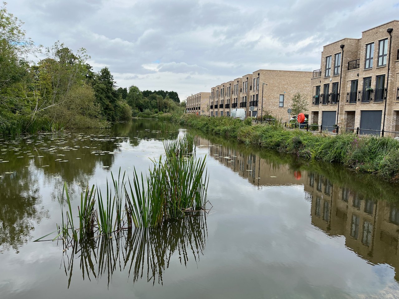
The neighbourhood responds directly to surrounding uses, forms, activity, and its historic legacy of the mill. This response creates unique morphologies which interact with diverse nodes and spaces. While the site permeates the canal and open space to the northwest, there is a division between the site and surrounding forms. However, the site is able to support connectivity to the surrounding neighbourhood using nodes and typologies of built form.


Wolvercote stands out from it’s surroundings due to it’s tighter urban form, creating a distinct character.
1. The layout aims to reference the site’s previous use as a mill, creating long rows of housing and large boxy apartment buildings to mimic the old factory buildings.
2. There are three key character areas: the entrance plaza, the north-eastern mews, and the waterfront.
3. Large apartment buildings surround the public plaza as you enter the site.
4. Mews of terraced housing extend off the plaza.
5. The surrounding environment to the east, south and west is protected under a conservation area due to it’s distinct and untouched landscape character. This impacts the buildings around the south of the site, which have a more traditional stone facade to fit in with historic architecture.

Overall a transport network that improves the permeability of the area compared to the surrounding cul-de-sac typologies, while also connecting into public transportation and recreational footpaths. The hierarchy of streets respond directly to different frontages and the uses of spaces.
6. Collett Drive serves as the main spine for the single access to the site by public transport, active travel, and vehicles. This street has unique frontages of which side permeates into adjacent forms.
7. Goff street provides a unique urban morphology between the edge of development and waterfront.

Activity in Wolvercote is defined by punctual nodes of activity around key open spaces and socio-economic uses along Godstow Road.
8. There are three main nodes identified in the area with a clearly central node where most social activity (meeting, playing, eating) takes place.
9. The most recent community hub building is located within this central node, which despite being part of the Wolvercote Mill development, its key location, serves the wider community.
10. There are two other nodes of activity relating to the new development at Wolvercote Mill. While the first is centrally located to the key routes, bus stop, and its connection to the main access to the site, the second is centred on play as the main activity and access to the retained woodland.

The site is surrounded by open countryside which permeates into the northern end of the site.
There are a number of waterways running around the site:
11. Wolvercote Mill stream runs along the western edge of the site.
12. Wolvercote lakes is located on the eastern edge of the site.
13. A canal runs just outside the eastern border.
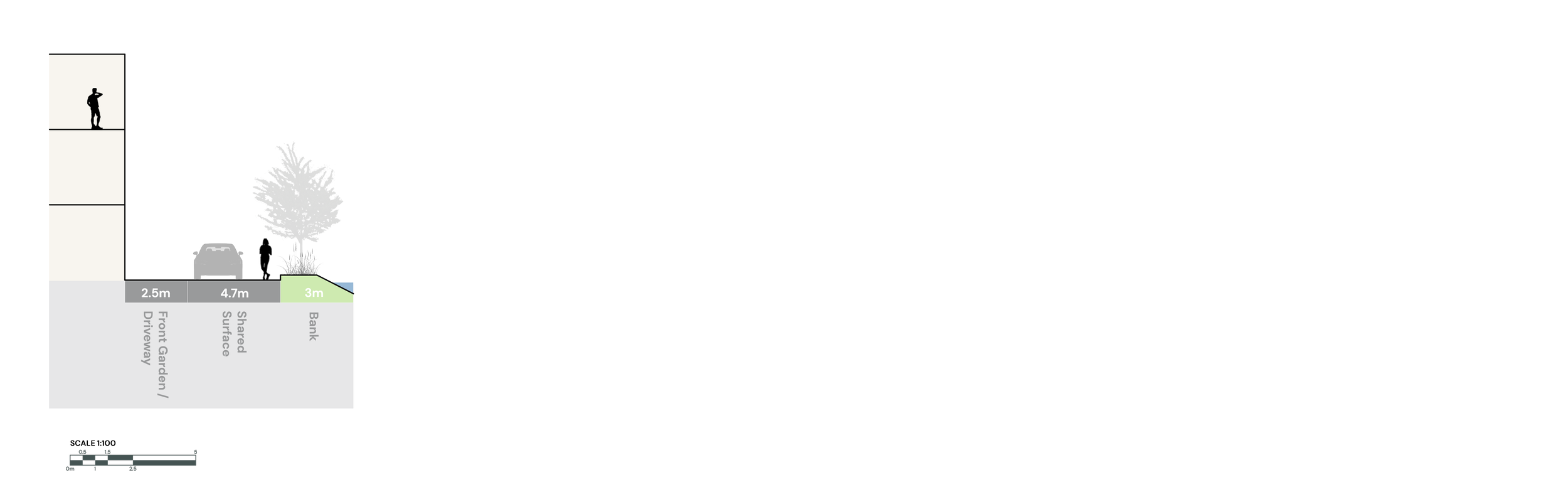
STREET – Collett Drive
Collett Drive forms the western edge of the development, where a block-paved street with low kerbs gently curves to reveal the frontages of modern, high-pitched, two-storey homes. Each home features Juliet balconies, and those on the west side of the street benefit from small front gardens that help to green the area. On the eastern side, a wildflower verge adds a natural touch to the streetscape, though the street trees within it appear to have struggled, with many showing signs of failure. On the opposite side, a narrow footpath runs along the length of the street, providing limited space for pedestrians to move between the northern and southern ends.


Collett Drive section
STREET – Goff Street
Forming part of the western edge of the development, this is a narrow, shared-surface, one-way street running alongside the millpond. The built edge is strongly defined by a repeating pattern of 3 storey rectilinear properties, with large windows, balconies and terraces on the upper floors and integral garages on the ground floor. A raised kerb and railing provide a robust barrier to the waterfront edge.


Goff Street section
SPACE – Wolvercote Mill
Initially used as a show room this space was designed to be used as a community hub after sales were completed. A clever approach that could be adopted in many schemes. The overall success of this simple community space and building, is that it acts as a gateway between the new and old neighbourhoods. It is also a great example of strong ownership and management by the local people. It now provides an accessible and affordable place for people to meet and engage in community activities.


Wolvercote Mill plan
SPACE – Papermill Square
The quality of design approach in wider arrangement, as well as hard and soft materials are not continued from the rest of the development. For example, there are no wildflowers (as elsewhere), but instead only standard amenity planting. Similarly, the broader space is dominated by expansive asphalt surfaces and has a very limited range of functions considering it is intended to be the main central community space.


Papermill Square plan
Summary
Key Place Analysis take-aways:
Industrial DNA drives morphology: Long terraces and boxy apartment blocks consciously echo the former paper-mill sheds, giving the scheme a compact, orthogonal grain that contrasts with the looser surrounding village fabric.
Clear character zones. Arrival plaza, north-eastern mews and canal-edge waterfront each have a distinct frontage mix and scale hierarchy that aids way-finding and identity.
Permeability without cut-through: A single main spine (Collett Drive) and a slender shared-surface edge (Goff Street) stitch the site to bus routes, footpaths and the canal tow-path while discouraging through-traffic.
Activity organised around three nodes: The adaptable community-hub gateway, a play-focused woodland edge and a central mixed-use plaza concentrate social life; however, Papermill Square underperforms due to dominance of bus route, resulting in over-hard surfacing and limited programme.
Landscape stitched to wider ecology: Retained streams, lakes and new wildflower verges pull ecology into the neighbourhood, though street-tree failures signal management challenges.