
As part of our ongoing Place Research, we took a look at Upton urban extension. Once a test bed for approaches and aims that have since become standard practice, this strategic development has set a template for incorporating key layers of sustainability from Social Diversity, to Environment, Long-term Biodiversity, Local Identity and Liveability. The scheme was led by a prototype design code, which is now standard practice, but back then it was entirely new.
In conclusion, Upton now comprises 1,400 dwellings, with an average density of 52 dwellings per hectare, 22% of which are affordable homes and 100% are rated BREEAM ‘Excellent’. Whilst it provided a prototype for contemporary creative design solutions, we set out to review its real-world success twenty years on, to see how well this early model has stood the test of time. This process was useful to inform thinking and to reflect on the success of our own design coding approaches. At Upton, we found some aspects to be highly successful, promoting the value of design coding, though as an early approach, we found some important aspects to be missing.
The Neighbourhood
1. The design code has ensured a consistent block structure and logical street hierarchy across the site, as well as detailed public realm standards, down to materials and street furniture, as well as allocation of abundant green space including sustainable drainage, though lacked detail on the character or form of architecture/landscape.
2. Success of early phases in the south central /south east areas deliver the core principles of design code, and combined with the high quality of architecture and landscape quality delivered by the developers, it was driven by a competitive housing market and healthy competition between developers.
3. Later phases show a rather stark character shift from the earlier areas, with reduced consistency in application of the original vision’s design quality, especially in the much reduced architectural detail and very basic planting (often entirely lacking). The reduced consistency was largely down to reduced competition in a constrained housing market after the 2008 economic downturn.
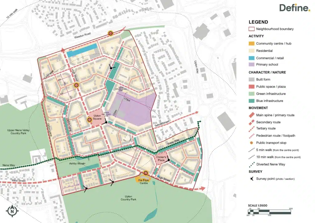

There are four character areas: Urban Boulevard, Neighbourhood Spine, Neighbourhood General, and Neighbourhood Edge. Character areas are driven by the phasing of the development.
1. There are three urban block typologies: Courtyard Blocks, Mews Blocks, and Neighbourhood Edge Blocks. These had more effect on the character.
2. Though there is an overall visual cohesion in pattern and block structure as laid out by the design guide, there is a high variation in building typologies and material palettes across the various stages of development. Stronger design guidance on architectural types and language could have ensured both a dynamic character but with more consistent standards for style and quality.
3. Resident’s parking is provided within communal courtyard parking (average 1.5 parking space / unit). Hence, this should result in minimal car dominance in the public realm. The extensive use of communal parking courtyards may create a large number of inactive spaces.
4. The school is wrapped with residential single-aspect blocks. The main school access is provided directly from Upton Square and vehicular access is from the other side of the block. It is recommended to understand how the school drop-off area is incorporated.

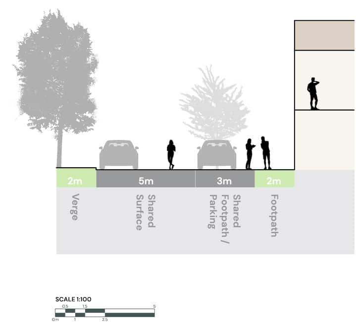
5. A defined street network hierarchy, with five key street typologies: Main Street, Streets with SUDS, Streets, Lanes, and Mews. This enhances permeability, encouraging movement and presents a legibility of pedestrian experience.
6. The transition between primary, secondary, mews is mirrored by the change of surface material; street width; traffic-calming measures. This slows traffic and promotes walkability, though pedestrians are less prioritised in main streets/higher order routes.
7. Linkage to existing diverted PRoW (Nene Way) which runs through site connects to adjacent amenity networks, encouraging movement in-out of Upton.

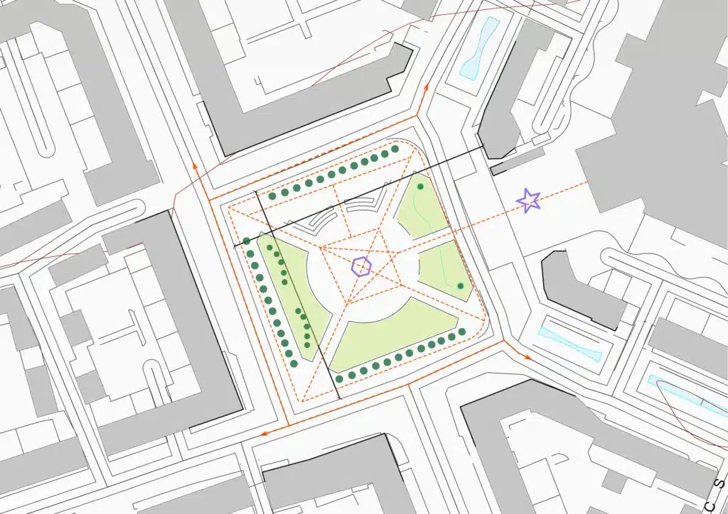
8. Deeper consideration could be given to variation of events to activate the two main public open spaces. Unfortunately, Upton Square and Clicker’s Place do not focus enough on the non-residential uses. This missed opportunity reduces potential for vibrant activity.
9. Main commercial/retail area is located on Weedon Road, which is not the most appropriate/ successful location (supported by Space Syntax analysis). We believe it would be better with reduced allocation, separated and integrated along the high street, through the site.

10. The masterplan presents a connected network of green spaces but these are applied inconsistently, reducing across the site. For example, the tree planting cover to the North into existing Ashby Wood woodland has regular breaking points, disconnecting potential ecological networks.
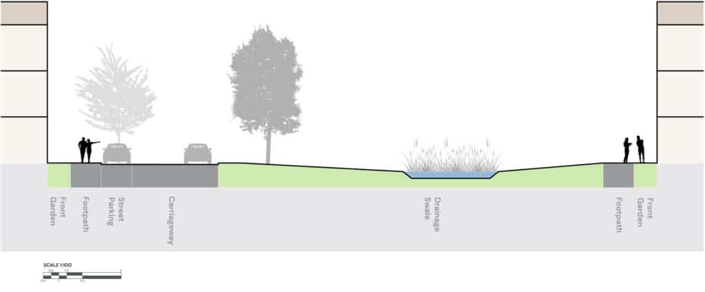
11. SUDS networks in the first phase have deep basins (Southern areas), reducing opportunities for an accessible amenity feature which could encourage water play and ecology planting strategy which might better connect people to nature. Though the later phases are shallower (to the North and West), they still do not promote these aspects.
12. Swales are inconsistently positioned. Those on north-south axis trees are situated in the centre of the street, whereas swales on east-west axis are situated to the side of the street. Hence, only some maximise sunlight onto streets.
STREET – Knot Tiers Drive
Knot Tiers Drive forms part of the northern edge of the development, where three-storey buildings line the street. The western side features terraced houses, while the eastern side is dominated by apartment blocks. The built form varies significantly across the road, with distinct architectural styles and materials giving each side a unique character. The street’s design is highlighted by a block-paved footpath, with evenly spaced tree planting and robust kerbs. The central SUDs corridor is bordered by a steel knee rail and has minimal planting; access to this green space is intentionally limited.
STREET – Parkside
This long, straight edge street defines part of the southern edge of the built development, with residential frontage overlooking an extensive area of country park and playing fields further to the south. Forming one of the earlier phases, large contemporary properties along this edge provide a strong sense of enclosure, with large three storey gabled features particularly prominent at the western end (see section below). The use of block pavers, kerbs and a central granite strip provide a distinctive surface treatment and help to slow traffic. Shared use by pedestrians is implied, although there are few physical connections between the edge street and the neighbouring open space. In some areas, parked cars and landscaping can be barriers to pedestrian movement.
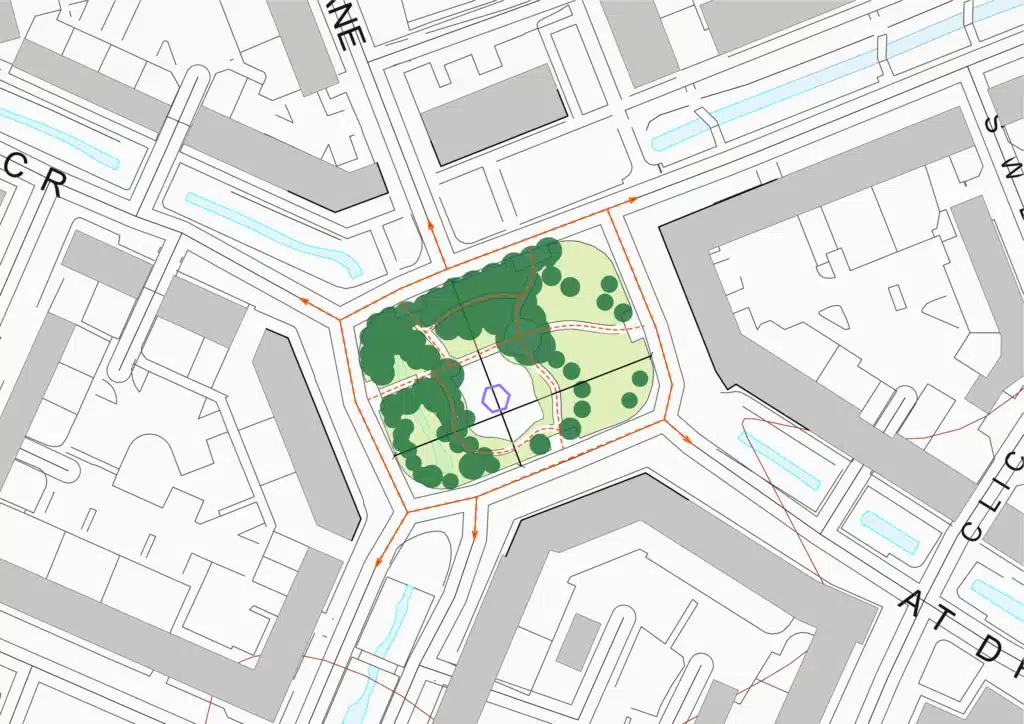
SPACE – Upton Square
The site offers significant potential for enhancing community engagement and vibrancy, particularly through its nodal, multi-use function and the presence of a primary school and fountains. However, improvements are needed in material quality, maintenance, and the diversity of uses to create a more distinctive and inviting atmosphere. While safe pedestrian access is commendable, better wayfinding and clearer routes for active travel would enhance connectivity. Additionally, the trees, although framing the square, require attention to height and biodiversity, and the central drainage system could be optimized in light of successful adjacent sustainable drainage practices. By addressing these elements, we can transform the space into a lively, multifunctional hub that resonates with the community.
SPACE – Clicker’s Place
The park feels safe and welcoming, with minimal lighting and a naturally bright play area. Materials are high quality and cohesive, with well-weathered details like bridges and decking. Movement is intuitive and informal, with gated entrances and a fully enclosed play area for children aged 4-11, though this limits use by older children.
Natural elements, such as accessible SuDS, diverse trees, and eco-decking, encourage interaction with nature. Additional planting near the fence could enhance the space while maintaining safety. Informal use of the swale for running and cycling highlights the park’s versatility, complemented by communal seating
Summary
Key Place Analysis take-aways:
Prototype design-code proved its worth, then frayed: Early phases delivered high-quality architecture and landscape, but post-2008 phases slipped in detailing and planting as market competition waned.
Robust block + street framework: Courtyard, mews and edge blocks sit within a five-tier street hierarchy, giving legibility and walkability; communal courtyards, though, often feel inactive and poorly overlooked.
Four character areas, one vision gap: Urban Boulevard and Spine hold the original code’s intent; but later Neighbourhood General/Edge areas dilute material and planting quality, eroding cohesion.
Public realm misses economic anchors: Upton Square and Clicker’s Place are spatially generous but lack ground-floor uses and varied programming, muting civic life; main retail centre stranded on Weedon Road limits internal vibrancy.
Green-blue infrastructure uneven: SuDS, swales and tree corridors were pioneering, yet depth, access and connectivity vary north–south, breaking potential ecological and play networks.


