

Introduction
Celebrating 10 years of practice, we set about reflecting on what we do at Define to understand and make great Places. This entailed formalising our methods, with the aim to systematically record, analyse and compare our place analysis. Kicking thing off, we set up a mixed expertise Place Research steering group to explore and test ideas. We felt it was important for these approaches to connect to live on site assessment to get a true feel for the Places we were to review. Following an extensive exploratory phase, we tested and increasingly refined our approach towards the creation of a toolkit for everyone else in the office to use independently in further place research.
I joined Define in 2022 to instigate and head up the Place Research process. As a lecturer, researcher, Urban Designer and Landscape Architect, I see that the Place Research approach we have conceptualised, tested and refined over the last year makes some important links between practice and academic approaches.
This first article provides a brief overview of our overall approach. We also have a number of specific Place Research projects that we will be coming to the website soon. Keep an eye out for the following places analysed during the first phase (2023):
- Bournville – contemporary appreciations of this visionary Victorian Birmingham Neighbourhood
- Jewellery Quarter – post-industrial transition to mixed-residential of this unique Birmingham heritage area
- Balsall Heath – varying functionality of this highly diverse, ad-hoc Birmingham area
- Ebbsfleet – newly completed, framework led, mixed-developer neighbourhood in former quarry, exploring best practice for health and sustainable living
- Accordia – unique highly contemporary housing development, setting a quality standard for Cambridge and the UK
If you would like to enquire about your own place research project, please get in touch to discuss.
What we do
Our Approach – Feasible, Adaptable, Comparable
Our unique place research approach allows us to efficiently collect and evaluate data to understand the essence of place success. We provide an effective and speedy overall assessment of places where we identify and highlight the key physical and socio-economic factors that influence a place’s quality. We use these evaluations to provide overall support to the planning and design process, supporting our depth of decision making and to pin-point areas for reflection on best-practice.
Our Place Research Categories
From our extensive collective experience, the Place Research team has defined the key layers that we feel have the most significant impact on the quality of a place. We also referred to a range of sources to inform our thinking. This included a critical review of policy and guidance examples, including the The UK gov. National Design Guide (NDG) and Streets for a Health Life (SfHL) – as referred to below.

Following a reflective process, we developed our approach to focus on a holistic analysis. The aim is to provide a solid overview within a relatively quick turn-around, using effective and efficient approaches. This follows analysis using 4 categories.
![]()
The categories connect two key scales. At the larger scale, we look at what makes a successful 1. Neighbourhood, via an assessment of it strategic arrangement and allocations.
This feeds in to Local scale analysis of key 2. Streets and Spaces, understanding how their material, space and socio-economic qualities contribute to success.
Our Approach to Neighbourhood Analysis
We start to really understand Places at the neighbourhood scale. This is achieved by viewing the structures that influence how efficient, sustainable and lively places can be. Outputs from this process are used to support strategic scale decisions around the arrangement and provision of neighbourhoods. The aim is to better understand the key strategic planning and design factors which influence the sense of place and level of social-interactions.
Starting with initial desktop-based processes, we collect base info and review and draw up sketch analysis. We use a matrix, with layers of analysis to ensure consistency of analysis and to allow comparison of one place to another.

Each place-research project is undertaken by a mixed discipline team to capture a range of perspectives.
Our Approach to Local Analysis
Streets and Spaces. Streets: form the lifeblood of well-connected places, functioning both as a physical conduit for local, more sustainable movement and as a way to enhance social connection and ownership. We will gather evidence of how street typologies and their qualities of scale and range of functions can influence use.
Spaces: such as Parks, Plazas and Squares provide hubs that enable and promote a diverse range of community activities throughout the year. We will gather evidence on how the qualities of public space, including the extent, location and connection between facilities can influence the extent and types of use. Like the neighbourhood analysis we use carefully defined layers of analysis to ensure consistent analysis quality.
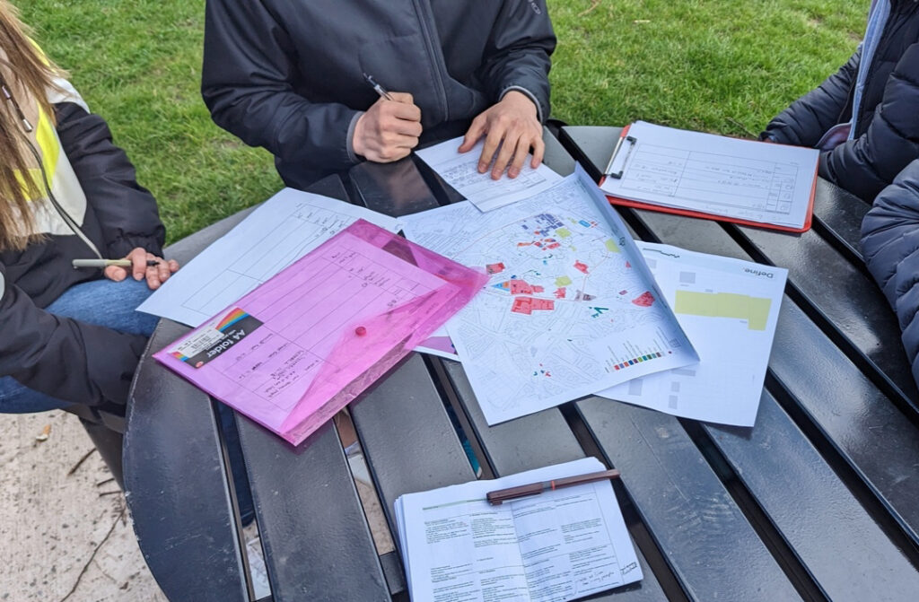
Team discussing their analysis on-site, supported by maps and note sheets
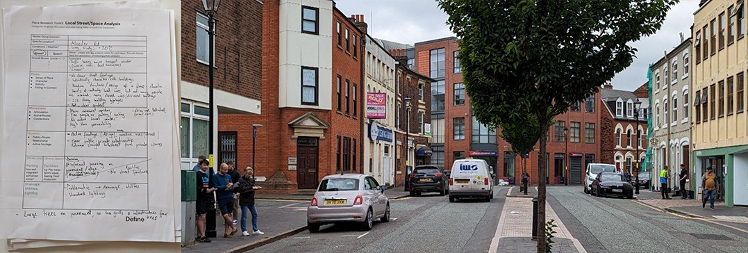
Photograph of Place research group and completed on-site analysis notes sheet
Overview of Process
Following a pre-site, ‘desktop’ review to identify the main areas of significance. For this, members of our multidisciplinary team, walk around and analyse specifically identified areas, taking photos at key points. Structured analytical notes were taken, informed by group discussion. Back at the office, these elements are drawn up to explain the place analysis into clearly defined visual methods.
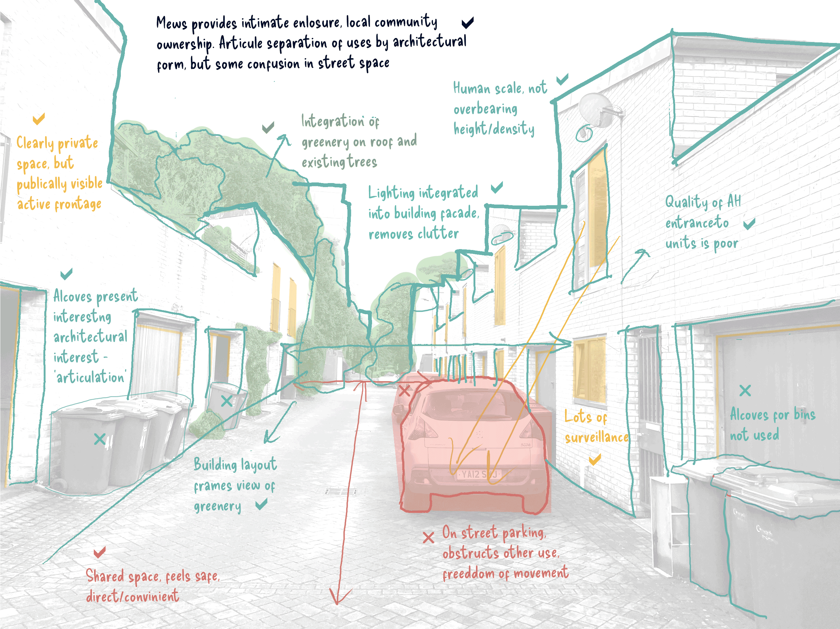
Place Analysis of a local Street in Accordia. Transitions into the original photo


